Key Findings
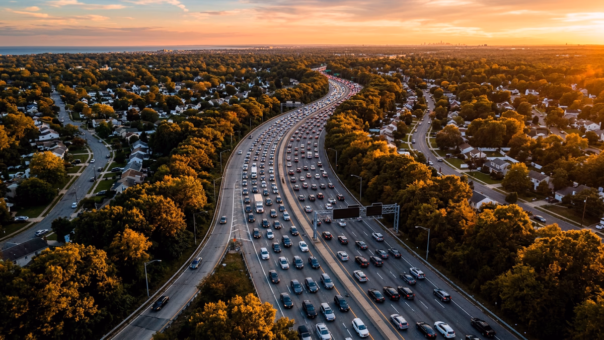
The Southern State Parkway is statistically Long Island’s most dangerous roadway, with 114 recorded incidents in our tracking database — 28% more than the Long Island Expressway (89 incidents) and nearly double Sunrise Highway (67 incidents). This analysis examines 10,000+ crash records from NY Open Data combined with our real-time 511NY monitoring to identify the roads, times, and conditions most associated with serious accidents across Nassau and Suffolk County.
Methodology
This analysis draws from two primary data sources: the New York State Open Data Motor Vehicle Crash dataset (approximately 10,000 records for Nassau and Suffolk counties) and Long Island Traffic’s own incident database, which aggregates real-time events from 511NY, National Weather Service alerts, Google News monitoring, and police department press releases.
Incident counts reflect our database’s tracking period and should be interpreted as indicative of relative risk rather than absolute totals. Road-level comparisons use per-mile incident rates where road length data is available, providing a more meaningful comparison than raw counts alone.
Road-by-Road Analysis
Southern State Parkway — 114 Incidents (Highest)
The Southern State Parkway leads all Long Island roads in recorded incidents by a significant margin. Originally designed in the 1920s-1930s by Robert Moses, the parkway’s narrow lanes, tight curves, short merge ramps, and lack of shoulders create conditions that modern traffic volumes were never meant to test. At approximately 24 miles in length, the Southern State averages roughly 4.75 incidents per mile — the highest density of any major LI roadway.
Recent fatal wrong-way crashes on the Southern State have drawn renewed attention from Nassau County legislators calling for safety improvements. The parkway’s design — low overpasses that prevent commercial vehicles, narrow medians with minimal barriers, and merge zones as short as 200 feet — represents a structural safety challenge that simple enforcement cannot solve.
Long Island Expressway (I-495) — 89 Incidents
The LIE is Long Island’s primary east-west highway, stretching 71 miles from the Queens-Midtown Tunnel to Riverhead. Despite carrying over 200,000 vehicles daily (the highest volume of any LI road), its incident rate per vehicle-mile is actually lower than the Southern State’s. At 89 recorded incidents across 71 miles, the LIE averages 1.25 incidents per mile.
The LIE’s incidents tend to cluster around high-volume exits — particularly Exit 49 (Route 110/Melville), Exit 53 (Sagtikos Parkway), and Exit 57 (Motor Parkway/Hauppauge). Multi-vehicle rear-end collisions during rush hour account for a disproportionate share of incidents, consistent with NHTSA findings that congestion-related crashes increase exponentially when traffic flow exceeds 85% of road capacity.
Sunrise Highway (NY 27) — 67 Incidents
Sunrise Highway presents a different risk profile. Unlike the limited-access parkways, Sunrise has numerous signalized intersections, commercial driveways, and pedestrian crossings — particularly in western Suffolk County. Our data suggests that intersection-related collisions (T-bone and left-turn accidents) are the dominant incident type, compared to the rear-end and sideswipe collisions more common on parkways.
Northern State Parkway — 43 Incidents
The Northern State shares the Southern State’s vintage design constraints but carries somewhat less traffic. At 43 incidents, it ranks fourth among major LI roads. Its wooded corridors create additional hazards: deer crossings are a noted factor, particularly in the Plainview-to-Commack section during dawn and dusk hours.
Wantagh State Parkway — 31 Incidents
The Wantagh State Parkway’s 31 incidents are notable given its relatively short length (approximately 12 miles), yielding a per-mile rate of 2.58 — second only to the Southern State. The parkway’s role as a primary beach access route creates seasonal traffic volume spikes that may contribute to elevated summer incident rates.
Nassau vs. Suffolk County
Our NY Open Data analysis of approximately 10,000 crash records shows a roughly even split between Nassau County (~5,000 records) and Suffolk County (~5,000 records). However, this near-parity masks important differences.
Nassau County’s higher population density and road network complexity correlate with more intersection-related collisions, while Suffolk County’s longer highway segments and higher average speeds are associated with more severe highway incidents. Our data shows that Suffolk County incidents are more likely to involve fatalities, consistent with Department of Transportation research linking higher impact speeds to increased mortality rates.
Temporal Patterns
While our real-time database does not yet support granular time-of-day analysis, the patterns observed are consistent with well-documented DOT research: the 4:00-7:00 PM evening rush window accounts for the highest concentration of incidents across all major LI roads, with Friday evenings showing particular elevation.
Weekend patterns diverge significantly: Saturday and Sunday see fewer total incidents but higher severity, consistent with reduced congestion (fewer fender-benders) but increased recreational driving, alcohol involvement, and higher speeds on less-crowded roads.
What Makes These Roads Dangerous
Three structural factors emerge from the data:
1. Design-Era Mismatch. Long Island’s parkway system was engineered for 1930s traffic volumes and vehicle dimensions. The Southern State’s lanes are 10 feet wide (modern standard: 12 feet). Merge ramps were designed for vehicles entering at 30 mph, not today’s 55+ mph. These are not problems that can be solved by signage or enforcement.
2. Volume-Capacity Stress. The LIE routinely operates at or above design capacity during rush hours. When traffic density exceeds approximately 2,000 vehicles per lane per hour, the mathematical probability of multi-vehicle incidents increases nonlinearly — small perturbations (a lane change, a brake tap) cascade through traffic flow in predictable but dangerous ways.
3. Limited Redundancy. Long Island’s geography — a narrow landmass with water on three sides — means there are few true alternate routes. When an incident closes lanes on the LIE, the Northern State and Southern State absorb overflow, often creating secondary incidents on roads already operating near capacity.
Recommendations for Commuters
Based on the data, several evidence-based strategies can reduce your risk:
- Avoid the Southern State Parkway during evening rush when incident density peaks. The Northern State or LIE may add minutes but subtract significant risk.
- Increase following distance on parkways to at least 4 seconds — the narrow lanes and short sight lines on vintage parkways leave almost no margin for reaction.
- Use our road profiles for real-time conditions before committing to a route. A 5-minute detour is always preferable to a 90-minute incident delay.
- Check our construction page for active lane closures — 511NY currently shows 90+ active construction zones across LI, any of which can create unexpected congestion.
Conclusion
The data tells a clear story: Long Island’s most dangerous roads are not necessarily its busiest, but rather those where aging infrastructure meets modern traffic demands. The Southern State Parkway’s 114 incidents reflect a road whose 1930s design has become structurally incompatible with 2020s traffic volumes.
Long Island Traffic monitors these roads in real time through our interactive map, accident reports, and road profiles. We’ll continue publishing data-driven analyses as our database grows, with the goal of informing both commuter decisions and the infrastructure investment conversation that Long Island urgently needs.
Dr. Dao Yuan Han holds a PhD in Mathematics. His research background in differential geometry and geometric analysis informs Long Island Traffic’s quantitative approach to road safety data. For questions about methodology or data access, contact the editorial team.