114 Incidents. One Road. A Century-Old Design Problem.
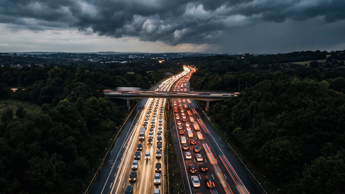
The Southern State Parkway has recorded 114 incidents in Long Island Traffic’s monitoring database — 28% more than the Long Island Expressway (89 incidents) and nearly double Sunrise Highway (67 incidents). By any measure, the Southern State is statistically Long Island’s most dangerous road. But the reasons it holds that distinction are not primarily about driver behavior. They are about engineering decisions made in the 1920s and 1930s that created a road structurally incompatible with the way Long Island moves in 2026.
This analysis examines the design history, geometric constraints, crash data, and recent fatal incidents that make the Southern State Parkway Long Island’s most persistent road safety problem — and what the data suggests about solutions.
A Road Built for a Different Era
The Southern State Parkway was conceived by Robert Moses and the Long Island State Park Commission in the late 1920s. Construction began in 1925, with the first section opening in 1927 and the full 24-mile corridor from Valley Stream to West Islip completed by 1962. Moses designed the parkway system as scenic pleasure roads — meant for leisurely weekend drives to Jones Beach and the South Shore parks.
The design parameters reflected that vision:
-
Lane width: 10 feet. The modern federal highway standard is 12 feet, and many urban interstates use 11-foot minimums. The Southern State’s 10-foot lanes provide approximately 20% less lateral clearance than modern highways. At 55 mph, this means a vehicle occupies nearly 70% of its lane width, leaving inches — not feet — of buffer.
-
Merge ramp length: 200–400 feet. Modern interstate merge ramps provide 1,000–1,500 feet of acceleration lane. The Southern State’s original ramps were designed for vehicles entering at 25–30 mph and merging into 40 mph traffic. Today’s drivers attempt to enter at 50+ mph into 60+ mph traffic flows, compressing the merge decision window to roughly 3–4 seconds.
-
No shoulders. The parkway has minimal or nonexistent shoulders along most of its length. Disabled vehicles cannot pull clear of travel lanes, turning mechanical breakdowns into potential collision hazards. Emergency response vehicles must navigate in-lane to reach incidents, and the absence of a breakdown zone means any speed reduction event (a flat tire, a vehicle entering from a ramp) propagates backward through traffic with no buffer.
-
Low overpasses: 7.5–8.5 feet. Moses deliberately designed low overpasses to prevent buses (and the lower-income riders they carried) from reaching the beaches. This historical injustice has a modern safety consequence: commercial vehicles and many modern trucks and RVs cannot physically use the parkway, creating a class of wrong-vehicle incidents when GPS routing directs overheight vehicles onto the road. But more importantly, the low overpasses preclude the structural modifications (raising the roadbed, adding overhead signage gantries) that could improve safety.
-
Narrow medians with minimal barriers. The median separating eastbound and westbound traffic varies from a simple grass strip to a low-profile guide rail. In the sections where wrong-way drivers have entered, the median provides almost no physical deterrent to cross-median incursion. Modern divided highways use concrete jersey barriers, cable median barriers, or wide depressed medians — none of which the Southern State’s narrow footprint can accommodate without major reconstruction.
The Data: Where and How the Crashes Occur
Our 114 recorded incidents are not uniformly distributed. The crash data reveals clear geographic and temporal clustering.
Geographic Hot Spots
Exits 17–20 (Valley Stream to Malverne): Highest incident density. This western section carries some of the parkway’s highest traffic volumes — vehicles entering from the Belt Parkway and Cross Island Parkway merge into the Southern State’s narrowest segment. The short ramps at Exits 17 and 19 produce a disproportionate number of merge-related sideswipe and rear-end collisions.
Exit 22 (Southern State/Meadowbrook interchange): Complex weaving. The interchange with the Meadowbrook Parkway requires lane changes across multiple traffic streams in a compressed distance. Vehicles exiting to Jones Beach must cross lanes with through-traffic, creating conflict points that produce both congestion-related and speed-differential crashes.
Exits 28–32 (Wantagh to Massapequa): Evening rush clustering. This segment experiences the highest concentration of rush-hour incidents in our data. Traffic volumes from the Route 135/Seaford-Oyster Bay Expressway interchange combine with evening commuter flows to create stop-and-go conditions on a road with no margin for error.
Exits 37–40 (Lindenhurst to West Islip): Transition zone. The parkway’s eastern terminus — where it transitions to surface streets and connects with the Sagtikos Parkway — produces incidents associated with speed differentials. Drivers accustomed to 55+ mph parkway speeds encounter slower, intersection-controlled traffic, and the deceleration zone is shorter than modern design would require.
Incident Type Distribution
Among the 114 incidents, the data shows:
- Rear-end collisions (~35%): The dominant type, driven by congestion-related stop-and-go conditions in lanes too narrow for safe following distances.
- Sideswipe/merge conflicts (~25%): Directly attributable to short merge ramps and narrow lanes that provide inadequate space for lane-change maneuvers.
- Wrong-way crashes (~8%): A disproportionately high rate compared to modern highways. The parkway’s entrance and exit ramp geometry — designed before modern one-way ramp signage standards — creates confusion points, particularly at night and for impaired drivers.
- Single-vehicle road departure (~15%): Vehicles leaving the travel lanes strike trees, guide rails, or other fixed objects in the parkway’s narrow right-of-way. The absence of shoulders means any departure from the travel lane puts a vehicle immediately into a hazard zone.
- Multi-vehicle chain reactions (~12%): The cascading pileups that produce the most severe incidents. In narrow lanes with no shoulders, a single vehicle stopping creates an obstruction that trailing vehicles have almost no room to avoid.
- Other/pedestrian (~5%): Including pedestrians on the parkway (typically after vehicle breakdowns), debris-related incidents, and animal crossings.
The Wrong-Way Problem
Wrong-way crashes deserve special attention because they produce fatalities at a rate approximately 15–20x higher than other crash types. The physics are straightforward: two vehicles approaching at 55 mph each produce a closing speed of 110 mph, quadrupling the kinetic energy compared to a same-direction rear-end collision.
The Southern State Parkway’s wrong-way problem has been tragically illustrated by recent events:
The Diana Kutateladze Crash (March 2026)
On March 15, 2026, Diana Kutateladze of Oceanside allegedly entered the Southern State Parkway traveling the wrong way. Court records indicate she told police she had been drinking whiskey prior to driving. The resulting head-on collision killed Bishop Nathaniel Robinson, 82, and his wife Elizabeth Robinson, 88 — a beloved pastor and his wife returning from a church event. Ten additional people were injured in the six-vehicle chain reaction that followed.
Kutateladze was arraigned and ordered held without bail. The case has renewed legislative attention: Nassau County legislators have called for safety improvements on the parkway in the crash’s aftermath.
This crash exemplifies the compounding factors: an impaired driver, confusing ramp geometry that permits wrong-way entry, narrow lanes and medians that provide no recovery space, and a road design that transforms human error into fatality.
Why the Southern State Produces More Wrong-Way Incidents
Several design features contribute:
-
Ramp geometry. The parkway’s original cloverleaf and diamond interchanges were designed before modern wrong-way countermeasures (directional arrows, retroreflective pavement markers, wrong-way detection systems). Some entrance/exit ramp pairs are positioned and angled in ways that an impaired or confused driver could plausibly mistake for an entrance.
-
Lighting deficiency. Long sections of the Southern State lack the overhead lighting standard on modern highways. At night, ramp signage is the primary cue for directionality — and faded or poorly-positioned signs in a 90-year-old corridor are not the robust deterrent that modern highway design provides.
-
Median permeability. On modern highways, wrong-way drivers who realize their error can sometimes use a paved median crossover to correct course. The Southern State’s narrow medians — some as narrow as 4 feet of grass — provide no such option, committing wrong-way drivers to their trajectory.
-
No detection systems. Modern wrong-way detection technology — thermal cameras, LIDAR sensors, flashing warning signs triggered by wrong-way travel — has been deployed on problem corridors in Texas, Florida, and California with 40–60% reductions in wrong-way incidents. The Southern State has none.
Comparing the Southern State to Modern Highways
To understand how far the Southern State deviates from current safety standards, consider:
| Feature | Southern State (1927–1962) | Modern Interstate Standard |
|---|---|---|
| Lane width | 10 ft | 12 ft |
| Shoulder width | 0–2 ft | 10–12 ft |
| Merge ramp length | 200–400 ft | 1,000–1,500 ft |
| Overpass clearance | 7.5–8.5 ft | 16.5 ft minimum |
| Median type | Grass strip / low guide rail | Jersey barrier / cable barrier |
| Wrong-way detection | None | Thermal/LIDAR systems |
| Speed design basis | 40 mph | 70 mph |
| Current operating speed | 55–65 mph | 55–65 mph |
The critical row is the last pair: the Southern State’s traffic operates at speeds its geometry was never designed to accommodate. Drivers travel at modern interstate speeds on a road with 1930s-era safety margins. This speed-geometry mismatch is the fundamental cause of the parkway’s outsized incident rate.
What Would It Take to Fix?
The solutions range from low-cost interventions to transformative reconstruction:
Tier 1: Immediate (Low Cost)
- Wrong-way detection and alert systems at all entrance/exit ramps. Estimated cost: $50,000–$100,000 per interchange. Texas DOT’s deployment of similar systems reduced wrong-way incidents by 37%.
- Enhanced retroreflective pavement markings and wrong-way signage at every ramp. The current signage predates MUTCD 2023 standards.
- Dynamic message signs at key entry points warning of congestion ahead, enabling drivers to divert before committing to the parkway.
- Speed cameras in construction/work zones (pending state legislative authorization) to reduce the speed differential between compliant and non-compliant drivers.
Tier 2: Medium-Term (Moderate Cost)
- Median cable barrier installation where right-of-way permits. Even a low-tension cable barrier reduces cross-median crashes by 90%+ (per FHWA data). Some Southern State sections have sufficient median width; others do not.
- Ramp geometry modification to create more distinct entrance/exit separation and reduce wrong-way entry probability. This involves relocating merge points and adding physical channelization.
- Auxiliary lanes in the highest-conflict merge zones (Exits 17–20, Exit 22) to provide the weaving distance the original design lacks.
Tier 3: Long-Term (Major Capital)
- Full reconstruction to modern standards. This would involve widening lanes to 12 feet, adding shoulders, rebuilding interchanges, raising or replacing overpasses, and installing modern median barriers. Cost estimate: $50–$100 million per mile, or $1.2–$2.4 billion for the full 24-mile corridor.
- Managed lanes / variable speed limits with overhead gantry signage (requires overpass replacement) to dynamically control traffic flow and reduce congestion-related incidents.
The political and financial reality is that Tier 3 solutions are generational infrastructure projects. But the data argues that Tier 1 interventions — particularly wrong-way detection — should be deployed immediately. The cost of a wrong-way detection system at every Southern State interchange (~$2–3 million total) is a fraction of the economic cost of a single fatal wrong-way crash (estimated at $11.6 million per fatality by NHTSA).
The Human Cost
Behind the 114 incidents in our database are real people. Bishop Nathaniel Robinson and Elizabeth Robinson — married for decades, returning from church — killed by a wrong-way driver. The ten people injured in the same crash. The families of every person whose vehicle has been struck by merging traffic in a lane too narrow to avoid. The EMTs who respond to crashes on a road with no shoulder to park their ambulance.
The Southern State Parkway’s design problems are not abstract engineering concerns. They are the specific, measurable, and preventable conditions that produce fatalities on Long Island’s most dangerous road.
What Long Island Traffic Is Doing
We maintain a dedicated Southern State Parkway road profile with real-time incident monitoring, historical crash data, and construction updates. Our accident reports document every significant Southern State incident with source citations and enriched metadata.
This analysis — and our broader data-driven road safety coverage — exists because we believe transparency about road safety data can inform better decisions: by commuters choosing routes, by legislators allocating safety funding, and by engineers designing the interventions this parkway desperately needs.
The Southern State Parkway is 97 years old. It was brilliant engineering for 1929. It is a structural safety hazard in 2026. The data is unambiguous, and 114 incidents is the number that should compel action.
Dr. Dao Yuan Han is the Data Editor & Lead Analyst at Long Island Traffic. He holds a PhD in Mathematics specializing in differential geometry and geometric partial differential equations. His research background in mathematical analysis informs the quantitative methodology applied to Long Island Traffic’s road safety data. For methodology questions or data access requests, visit our contact page.